LC 00239: verschil tussen versies
Geen bewerkingssamenvatting |
Geen bewerkingssamenvatting |
||
| (10 tussenliggende versies door 2 gebruikers niet weergegeven) | |||
| Regel 1: | Regel 1: | ||
[[Bestand:Layer1 geentekst.jpg|gecentreerd|kaderloos|500x500px]] | |||
==== What is layer 1? ==== | |||
The first layer of the Multi-Layered safety concept is the layer of prevention and consists of of all permanent measures that reduce the probability of a flood. | |||
===== Layer 1 and the MLS concept ===== | |||
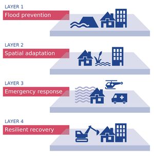
By using the Multilayered Safety (MLS) concept, different types of flood management measures are integrated, resulting in an overall reduction of the probability and the consequences of floods. MLS consists of four layers. Prevention is the first layer of MLS. The second and third layers are consequence-reducing measures, namely spatial solutions (layer 2) and emergency response (layer 3). Layer 1 and layer 2 are physical measures, whereas the third and fourth layers, crisis management and recovery, concentrates on organizational measures. Together, these layers can be tailored to local areas in order to minimize flood damage. | |||
[[Bestand:4layer illustratie totaal.jpg|gecentreerd|kaderloos]] | |||
==== What measures were taken in the FRAMES pilots in this layer? ==== | |||
Neither of the FRAMES pilots focused on this layer. | |||
==== What tools were used in the FRAMES pilots in this layer? ==== | |||
FRAMES has compiled a list of tools used in the pilots and classified these per layer. Click {{Internal link|link=PR 00153|name=here|dialog=process-linkpage-dialog}} to find out what tools are available for layer 2. | |||
{{Light Context | {{Light Context | ||
| Regel 15: | Regel 18: | ||
|Supercontext=PR 00274 | |Supercontext=PR 00274 | ||
|Topcontext=PR 00069 | |Topcontext=PR 00069 | ||
|Heading= | |Heading=Layer 1: Flood protection | ||
}} | }} | ||
Huidige versie van 8 jul 2020 om 11:03
What is layer 1?
The first layer of the Multi-Layered safety concept is the layer of prevention and consists of of all permanent measures that reduce the probability of a flood.
Layer 1 and the MLS concept
By using the Multilayered Safety (MLS) concept, different types of flood management measures are integrated, resulting in an overall reduction of the probability and the consequences of floods. MLS consists of four layers. Prevention is the first layer of MLS. The second and third layers are consequence-reducing measures, namely spatial solutions (layer 2) and emergency response (layer 3). Layer 1 and layer 2 are physical measures, whereas the third and fourth layers, crisis management and recovery, concentrates on organizational measures. Together, these layers can be tailored to local areas in order to minimize flood damage.
What measures were taken in the FRAMES pilots in this layer?
Neither of the FRAMES pilots focused on this layer.
What tools were used in the FRAMES pilots in this layer?
FRAMES has compiled a list of tools used in the pilots and classified these per layer. Click here to find out what tools are available for layer 2.
Hier wordt aan gewerkt of naar verwezen door: Adaptive planning, Layer 1- Flood protection, Natural flood management


