Preparedness and emergency planning
What is a preparedness and emergency response?
Preparedness and emergency planning aims to support vulnerable people and areas susceptible to flood damage. This implies active risk communication by increased public awareness and preparedness and emergency response via contingency planning.
Preparedness and emergency response and FRAMES
The following pilot projects took preparedness and flood emergency actions:
- Alblasserwaard, Sloegebied (NL), Wesermarsch (DE) and Kent (UK) pilots aimed on integrating emergency response planning in flood risk management (and vice versa)
- Alblasserwaard, Reimerswaal, Slogebied (NL) and Wesermarsch (DE) pilots aimed to improve evacuation strategies (preventive evacuation, safe haven, shelters, vertical evacuation)
- British, Belgian, Alblasserwaard, Sloegebied (NL) and Wesermarsch (DE) pilots aimed to raise awareness for flood resilience measures.
How is preparedness and emergency response linked to MLS?
The implementation of preparedness and emergency planning measures benefits the other layers of the MLS approach:
- Layer 2, spatial adaptation: community groups support spatial adaptation planning such as flood proof zoning and NFM
- Layer 3, emergency management: raising flood risk awareness leads to capacity building among local community groups for flood preparedness and increases community resilience.
- Layer 3, resilient recovery: when flood preparedness measures are taken, it will lead to better flood recovery for communities.
Lessons learnt
For a full list of the main lessons learnt from the pilots working on preparedness and emergency response, please click here.
Relevant adaptive capacities
To accomplish actions successfully, certain capacities are more needed than others. More specifically: the combination of flood risk management strategies in response to climate change depends on the adaptation space and capacity of institutions (Berkhout, Hertin and Gann, 2006). Since institutions have the ability to stimulate the capacity of a society to adapt to climate change from the local to the national level (Gupta et al., 2010), stakeholders and organizations involved in FRAMES focused on the development of adaptive capacities at local and regional level.
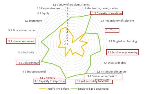
The adaptive capacities that were employed and developed during the pilot projects working on community resilience are shown in the spiderweb below. We will provide more detail for those capacities that significantly increased during the pilots.
- Diversity of measures: combine actions. Low flood risk awareness causes problems for preparedness and emergency planning strategies. By combining several preparedness and emergency planning actions, flood resilience will increase.
- Trust: creating trust is the first step towards success. In the FRAMES pilots, the local authorities built trust with local community groups involved in the projects such as citizens, schools, farmers and landowners.
- Access to information: raise awareness. Stakeholders who are not directly involved in flood risk management might also have low(er) risk awareness. By giving them access to information about the flood risk in their area, this awareness should increase. In FRAMES, new innovative approaches have been developed to raise awareness of many different types of stakeholders: specific information leaflets for farmers and landowners (Wesermarsch, UK), school programs (Belgium) and risk assessments for businesses (Alblasserwaard, Sloegebied area). Communication initiatives for the public included articles in newspapers and magazines, items for (local) television and radio, a stopmotion film about MLS and regional MLS flood risk management days.
- Capacity to improvise: by raising awareness about flood risks among citizens and other stakeholders, social capacity will also improve / increase
- Act according to plan: ensure leaflets, manuals and leaflets are clear enough so citizens can actually follow the advice given and be better prepared in case of a flooding event.
- Double loop learning: integrate the layers. In several pilots (Alblasserwaard and Sloe in the Netherlands, Wesermarsch in Germany) crisis management has been combined with flood protection and spatial planning. Risk analysis (flood scenarios) and spatial analysis about evacuation strategies, and shelter locations, has been combined with behavioural studies to develop new frames for evacuation planning. In short, provide new ways to improve local evacuation strategies
- Human resources: successful projects will increase knowledge. The FRAMES pilot projects generated new knowledge and increased social capacity are valuable resources ; both are expected to last beyond the lifetimes of the projects.
- Likewise, the collaboration improved between water, crisis management authorities and local community groups.
Referenties
- Guide to dynamic planning Assens Vejle, Danish Coastal Authority, Danish Coastal Authority, 30 mei 2020.
- Medway Flood Action Plan, Environment Agency, 1 november 2017.
- Stakeholder analysis report FRAMES, FRAMES Consortium, 1 januari 2020.
- Adaptive capacities FRAMES definitions and examples, Gupta et al, 20 april 2020.
Hier wordt aan gewerkt of naar verwezen door: Layer 3- Preparedness and response, Lessons learnt RL

